Context
The Agence Foncière Rurale (AFOR) is a body dependent on the Ministry of Agriculture of Côte d’Ivoire responsible for implementing land tenure security activities in accordance with the orientations and priorities set in the declaration of rural land policy for Côte d’Ivoire. ‘Ivory 2017.
The Agency is the contracting authority for several land tenure security projects including the Project for the Improvement and Implementation of Rural Land Policy (PAMOFOR) financed by the World Bank. This project provides for the production over five years of 54,000 land certificates in 6 regions of the Republic of the Ivory Coast through the conduct of integrated land security operations.
In this context, and with the support of PAMOFOR, AFOR has decided to contribute to the modernization of the geodetic infrastructure of Côte d’Ivoire:
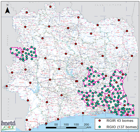
- By financing the physical rehabilitation of the 43 geodetic vertices of the Ivorian Reference Geodetic Network (RGIR) and 137 geodetic vertices of the Operational Ivorian Geodetic Network (RGIO) located in the PAMOFOR areas.
- By supporting the observation, calculation and compensation of the geodetic network (complete RGIR) and RGIO for the vertices located in the PAMOFOR zones.
- By supporting the establishment of a network of 5 permanent GNSS stations (CORS).

For this, AFOR wished to recruit an individual consultant to assist BNETD-CIGN in project management and supervision of the improvement and modernization.
Following a qualification process by Call of Expressions of Interest, and in view of his CV and professional experience, the application of Bertrand Boullard, manager of the TopoSat company, came out first and was retained.
The contract took effect on July 17, 2020 for a period of one year.


